


BVI地理与气候介绍
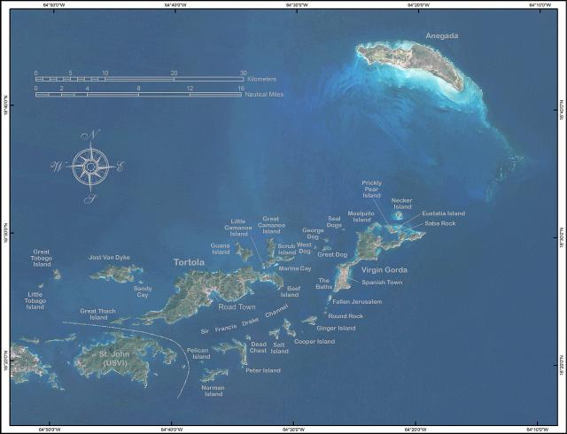
英属维尔京群岛位于加勒比海,在加勒比海和北大西洋之间,在波多黎各以东。其地理坐标为 18°30'N 64°30'W。地图参考包括中美洲和加勒比地区。该地区总面积为 151 平方公里(约为华盛顿特区面积的 0.9 倍),包括 16 个有人居住的岛屿和 20 多个无人居住的岛屿;包括托尔托拉岛、阿内加达岛、维尔京戈尔达岛和约斯特范戴克岛。
陆地上没有水体。没有土地边界。有80公里的海岸线。海洋主张包括 3 海里(5.6 公里;3.5 英里)的领海和专属的 200 海里(370.4 公里;230.2 英里)捕鱼区。它属于热带湿润气候,气温受信风影响。它的地形由珊瑚岛组成,相对平坦。它有火山岛,地势陡峭,多丘陵。它的最低点是加勒比海,最高点是海拔 521 米(1,709 英尺)的萨奇山。它的自然资源是微不足道的。 在土地利用方面,2005 年的数据为 20% 的耕地,6.67% 的永久性作物和 73.33% 的其他。其自然灾害包括 7 月至 10 月的飓风和热带风暴。天然淡水资源有限(托尔托拉岛上除了少数季节性溪流和泉水外,大部分岛屿的供水来自井和雨水集水区)。它与附近的美属维尔京群岛和波多黎各有着密切的联系。
英属维尔京群岛属热带气候,受信风影响。全年气温变化不大。在首都罗德城,典型的每日最高气温在夏季约为 32 °C (89.6 °F),冬季约为 29 °C (84.2 °F)。
典型的每日最低气温在夏季约为 24 °C (75.2 °F),冬季约为 21 °C (69.8 °F)。每年平均降雨量约为 1,150 毫米(45.3 英寸),山区较高,海岸较低。降雨量变化很大,但平均最潮湿的月份是 9 月至 11 月,平均最干燥的月份是 2 月和 3 月。飓风偶尔会袭击这些岛屿,飓风季节从 6 月持续到 11 月。
The British Virgin Islands are located in the Caribbean, between the Caribbean Sea and the North Atlantic Ocean, east of Puerto Rico. Its geographic coordinates are 18°30′N 64°30′W. Map references include Central America and the Caribbean. The area totals 151 km² (about 0.9 times the size of Washington, DC) and comprises 16 inhabited and more than 20 uninhabited islands; includes the islands of Tortola, Anegada, Virgin Gorda and Jost van Dyke.
There are no bodies of water on the land. There are no land boundaries. There is 80 km of coastline. Maritime claims include 3 nmi (5.6 km; 3.5 mi) of territorial sea and exclusive a 200 nmi (370.4 km; 230.2 mi) fishing zone. It has a tropical, humid climate, with temperatures moderated by trade winds. Its terrain consists of coral islands, and is relatively flat. It has volcanic islands and is steep and hilly. Its lowest point is the Caribbean Sea and its highest point is Mount Sage at 521 metres (1,709 ft) above sea level. Its natural resources are negligible.
In terms of land use, it is 20% arable land, 6.67% permanent crops and 73.33% other as of a 2005 figure. Its natural hazards consist of hurricanes and tropical storms from July to October. There is limited natural fresh water resources (except for a few seasonal streams and springs on Tortola, most of the islands' water supply comes from wells and rainwater catchments). It has strong ties to nearby US Virgin Islands and Puerto Rico.
Climate
The British Virgin Islands enjoy a tropical climate, moderated by trade winds. Temperatures vary little throughout the year. In the capital, Road Town, typical daily maxima are around 32 °C (89.6 °F) in the summer and 29 °C (84.2 °F) in the winter.
Typical daily minima are around 24 °C (75.2 °F) in the summer and 21 °C (69.8 °F) in the winter. Rainfall averages about 1,150 mm (45.3 in) per year, higher in the hills and lower on the coast. Rainfall can be quite variable, but the wettest months on average are September to November and the driest months on average are February and March. Hurricanes occasionally hit the islands, with the hurricane season running from June to November.

上海港慈企业管理咨询有限公司,成立于2013年,得益于全球各国客户的支持和信任,七年时间港慈已在上海,深圳,香港,澳门,英国设立办事处,专业质素及服务水平备受政府,同行以及客户认同。
- 上海市浦东新区张江路505号展想中心大厦1楼1C-1D室
- 电话: 021-58646960
- 传真: 021-58647622
- Email: marketing@googcci.com
Copyright© 2013-2024上海港慈企业管理咨询有限公司 | 免责条款 | 沪ICP备13025125号-6 | 沪公网安备 31011502017841号